
How many of us are really aware of how much ‘native bush’ was removed by our forebears to create the productive farmland of Waikato today?
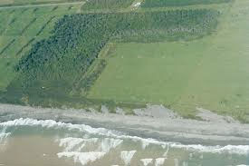
A photograph taken from high on the Mamaku Range facing toward Hauraki by ecologist John Leathwick showed a short burst of ‘indigenous ecologist biodiversity’ falling away to miles and miles of endless pasture, with hardly a tree or bush anywhere. As John says, once it would pretty well all have been bush clad with extensive wetlands.
A more accurate measurement, undertaken by the Waikato Regional Council, has shown clearance and drainage has reduced the extent of indigenous habitats in the region by 75 per cent, and 223 species of native plants and animals are threatened with extinction. Not a terribly good look.
Further measurements by the council have recently shown, despite various efforts to increase our biodiversity, we’re not making the expected progress.
So some months ago a group from the council, working with the ecological advancement firm Groundwork Associates, and individual contractors such as John Leathwick, began a pilot project focused on producing systems and guidance on a Local Indigenous Biodiversity Strategy, and called it Source to the Sea/Te Puna o Waihou ki Tikapa te Moana.
The chosen area was the Waihou catchment, as it represented all of the various land uses needing study, and they began with the Upper Waihou sub-catchments.
The intention is for the strategy to be incorporated into the Regional Policy Statement, using a significant change in approach from past rule-based efforts. It is now recognised that to deal with such issues on a regional scale requires cooperation and integration – both within and across organisations – that is underpinned by a strong values base – economic, social, cultural and environmental. Instead of having two mindsets facing off, the aim is to manage biodiversity and development working together.
Pilot project
The pilot project was carefully designed so its findings, and any ‘how to’ materials produced, could subsequently be confidently rolled out to the various district councils as well as to marae and other groupings within the region.
The photograph mentioned above formed part of a meeting recently held at Karapiro, where the various groups, including South Waikato and Matamata Piako district councils could share details of their current work strategies on biodiversity, and the pilot project team could give outlines of what work has been done so far, which has included a great deal of computerised mapping, on-ground examination of existing biodiversity, and interviews and meetings with landowners, marae members, and environmental organisations.
It appeared both councils are doing a lot of partnership work with individuals and groups, but so far with little coordination of results and on groundwork. This demonstrates the pilot project thinking based on cooperation and integration is very much needed for real progress to be made on increasing biodiversity along with the other associated benefits in economics, social and cultural areas aspired to.
Management plans
One of the major initial findings of the pilot is the need to assist farmers and landowners with property management plans. This ties in with other research carried out by the Healthy Rivers Project teams on freshwater management.
The concept was given hearty support by two experienced farmers who had received such assistance. By examining both their farming systems and their on-ground geography, they had been able to not only retain existing areas of bush, but to reorganise their land use into Land Management Units.
These had then allowed, in one case, a considerable increase in stocking rate, while simplifying animal movement, but also a marked saving in fertiliser costs, due to some land being retired and planted in trees.
In another case a steep face and creek near a patch of bush had been fenced according to contour, allowing for cattle to be excluded without the need for close riparian fencing and significantly reducing erosion potential.
However, in recent years most soil research has involved the creation of Land Use Capability criteria. These have, to date, been used as permission to use land for various purposes, but contained no detailed criteria on such factors as natural capital, soil stocks and long-term effects of such novel systems as irrigation and intensification.
It is now being realised a slightly different set of criteria, probably known as Land Management Units, also called LMU, would be more effective on individual properties, both short and long term.
Multiple issues
Workshop sessions later in the day looked at what could and should be incorporated in the desired ‘how to’ guide, and how issues such as training and choosing suitably skilled farm planners should be done. The general agreement was such plans should incorporate multiple issues including freshwater, soil types, biodiversity, farm profitability, and the potential for farm value if all these were done right.
Experience to date had shown one-on-one guidance for individual landowners would probably work best, as each farm is shaped and worked differently, and that advice should be consistent, and land and its usage focused. There had been a number of comments, from those interviewed, that advice from different individuals representing the same organisation could be very confusing.
As with other issues facing regulators at present, there are a number of organisations working on similar problems but with little collaboration, including government agencies. And farmers are not going to be impressed with a phalanx of ‘how to’ systems, nor with the prospect that each version would expect payment for its contribution. Collectivisation and cooperation would therefore have to be achieved for projects such as biodiversity enhancement to be fully incorporated into future efforts and plans.
0 Comments
Leave a Comment